What Remote-Sensing Reveals About Plants, Forests, and Minerals From Space
Remote sensing from space has transformed the way scientists observe Earth. By using satellites equipped with advanced sensors, researchers can study plants, forests, and minerals without physically visiting locations. This technology plays a crucial role in environmental protection, agriculture planning, climate studies, and mineral exploration.
What Is Remote Sensing From Space?
Remote sensing from space refers to the process of collecting information about Earth’s surface using satellites orbiting the planet. These satellites capture data through optical, infrared, and radar sensors. The collected data helps scientists analyze land, water, vegetation, and geological formations with high accuracy.
Unlike ground surveys, satellite-based remote sensing covers vast areas quickly and repeatedly, making it an efficient and cost-effective method for long-term monitoring.
How Satellites Study Plants From Space
Plants reflect and absorb sunlight differently depending on their health. Remote sensing from space uses this property to monitor vegetation conditions. Sensors detect reflected light in visible and near-infrared wavelengths, allowing scientists to calculate vegetation indices such as NDVI (Normalized Difference Vegetation Index).
These observations help in:
- Detecting crop stress and diseases early
- Monitoring drought impact on agriculture
- Estimating crop yield
- Planning irrigation efficiently
Farmers and governments increasingly rely on satellite data to improve food security and agricultural productivity.
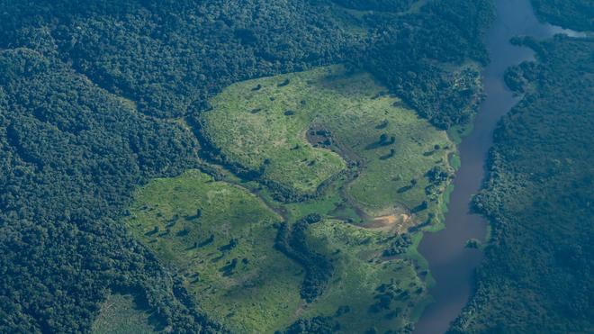
Monitoring Forests Using Remote Sensing
Forests are vital for biodiversity and climate balance. Remote sensing from space allows continuous monitoring of forest cover across the globe. Satellites track changes in forest density, canopy height, and biomass.
This technology helps identify:
- Deforestation and illegal logging
- Forest fires and burn severity
- Reforestation and forest regeneration
- Carbon storage and climate impact
Radar-based remote sensing is especially useful in forest monitoring because it can penetrate clouds and provide data even during night or bad weather.
Revealing Minerals Hidden Beneath the Surface
One of the most powerful uses of remote sensing from space is mineral exploration. Different minerals reflect and emit electromagnetic energy in unique spectral patterns. Satellite sensors can identify these patterns and map mineral-rich areas.
Remote sensing assists geologists in:
- Locating potential mining zones
- Reducing exploration costs
- Identifying surface alterations linked to mineral deposits
- Monitoring environmental impact of mining
Hyperspectral imaging is particularly effective for detecting specific minerals such as iron, copper, and clay minerals.
Role of Remote Sensing in Climate and Environment
Remote sensing from space provides critical data for understanding climate change. Satellites monitor melting glaciers, rising sea levels, changing vegetation patterns, and desert expansion.
Environmental agencies use satellite data to create policies for conservation, disaster management, and sustainable development.
Advantages of Remote Sensing From Space
- Covers large and remote areas easily
- Provides consistent and repeatable data
- Reduces human and financial risk
- Supports long-term environmental monitoring
With advancements in satellite technology and artificial intelligence, the accuracy and usefulness of remote sensing data continue to improve.
Future of Remote Sensing Technology
The future of remote sensing from space looks promising. High-resolution satellites, real-time data processing, and AI-driven analysis are making Earth observation more precise than ever. These innovations will further enhance our ability to protect forests, improve agriculture, and manage natural resources responsibly.
Conclusion
In today’s world, remote sensing from space is an essential scientific tool. From monitoring plant health and forest conservation to discovering valuable minerals, satellite technology provides insights that were once impossible. As technology evolves, remote sensing will continue to play a key role in understanding and protecting our planet.